
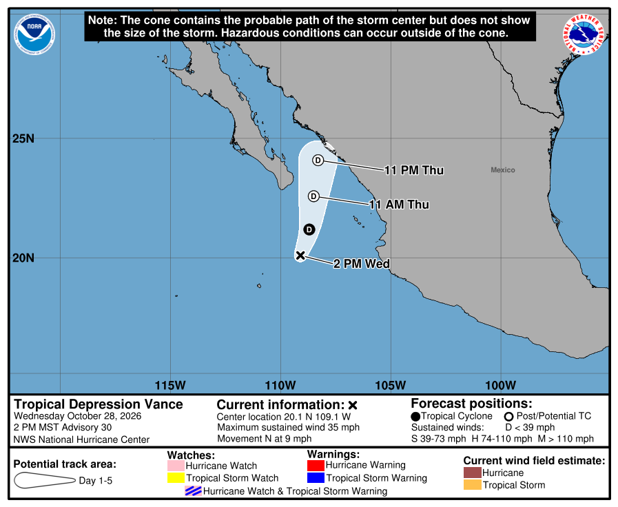
Tropical Depression Vance is weakening offshore but continues to pose a risk of heavy rain, flooding, mudslides and dangerous surf along parts of Mexico’s Pacific coast.
At 2pm MST on 28 October, the US National Hurricane Center located Vance about 320 miles (515km) west-north-west of Manzanillo and 220 miles (355km) west of Cabo Corrientes. The system had maximum sustained winds of 35mph (55km/h), was moving north at 9mph and had a minimum central pressure of 1,006 millibars.
No coastal watches or warnings were in effect. The NHC said Vance was expected to become post-tropical within 24 hours and dissipate soon afterwards, although hazardous conditions could continue after the system loses its tropical characteristics.
Through Thursday, Vance is forecast to produce between two and four inches of rain across central and southern Sinaloa, far south-western Durango and far north-western Nayarit. Isolated totals of up to seven inches are possible in central and southern Sinaloa. The rainfall could trigger flooding and mudslides, particularly in areas near steep terrain.
Swells generated by the system are expected to affect coastal areas of south-western and west-central Mexico, as well as the southern Baja California peninsula during the next few days. The NHC warned that the swells could create life-threatening surf and rip-current conditions.
The weather may affect swimming, surfing, boat excursions and other marine activities. Heavy rain could also complicate road journeys through mountainous areas, while hotels and tour operators should monitor local weather and civil-protection updates before operating excursions.
The latest advisory does not report a direct landfall or airport closure. Travellers heading to Mexico’s Pacific coast should nevertheless confirm marine activities and local road conditions before setting out.